| Visualizing the Impact of Indiana's Drug-Free Zone Laws | ||||||||||
|
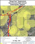
To help visualize the impact of drug-free zones in Indiana, we have created a series of maps, some showing the law as it currently is in Marion County, and others showing possible variations on that law. Of Indiana's 92 counties, Marion County (home to Indianapolis, the state capitol) has the largest population (860,000), greatest population density (2,172 per square mile), and the second greatest non-white population (30% compared to a statewide average of 13%). Focusing on Marion County shelps illustrate the extent of overlapping zones in urban areas, as well as the disparate impact of the current law on black and Hispanic communities. The first set of maps shows "drug-free zones" as they currently exist around schools, parks and family housing complexes. The second set of maps show what would happen if churches were added as protected sites, as proposed in 2007 (and what would happen to related "sex offender exclusion zones" if child care centers were added, as proposed in 2008). The third set of maps looks at the disparate impact of drug free zones on neighborhoods with different racial composition. The fourth set demonstrates problems of "superzones" that are created in some urban areas. The final set of maps shows various policy options created by shrinking the size of zones around various sites. Note: The maps are reasonably complete in regard to schools and public parks. Identification of all "family housing complexes" proved more difficult; thus the maps underestimate their number. The Indiana legislature has also created drug free zones around "youth program centers." That category proved to be so vague and potentially so large that we gave up trying to include any of them on our maps.
|


